このコーナーは家と歩道の境目にありますが、近所の方のおかげでいつもきれいな花が咲いています。
This sunflower is blooming in a tiny mound of dirt outside a neighbor’s house. I love how she maintains this corner and always offers some seasonal color to the passers-by.
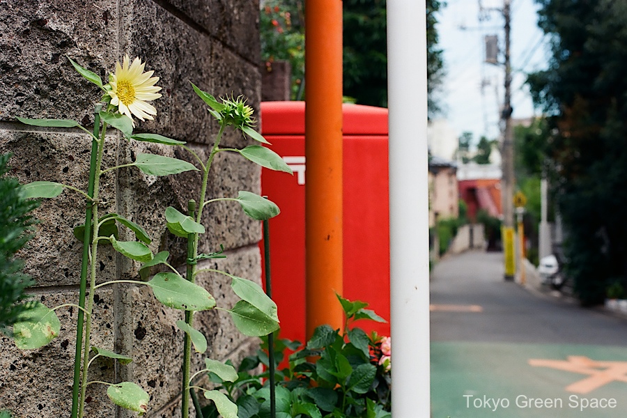
このコーナーは家と歩道の境目にありますが、近所の方のおかげでいつもきれいな花が咲いています。
This sunflower is blooming in a tiny mound of dirt outside a neighbor’s house. I love how she maintains this corner and always offers some seasonal color to the passers-by.

On my way to the sento, I passed this old house on a busy corner, across from a “family restaurant” featuring its own parking lot. In addition to a large sidewalk garden, the home features a welcoming dog above the mail box. I think the dog looks good with the new year decoration hanging above him.


I bike down this road so often, and suddenly I am surprised to see Mount Fuji at the very end. How come I am seeing it here for the first time? Maybe it’s the red of the sky against the traffic and brake lights.
Itsukaichi Kaido is one of the main Edo roads connecting Tokyo with western Japan. Near the city, it connects Koenji with Kichijoji while veering across and away from the Chuo train line. It also crosses the Zenpukuji river, which is a lovely greenway far from the train stations and mostly enjoyed by the neighbors.

西東京の9月の祭りは、旧街道の住民を繋げます。御神輿やお盆踊りや神社の祭りは地元の神を見えるようにします。秋の祭りも町の人々に農業の周期を思い出させます。音楽や衣装や銀賞や踊りが大好きです。特別の料理、提灯、お年寄りや高校生が集まって、普通の公共空間が生き生きとしてきます。
One of my favorite times in Tokyo are the September festivals, with portable shrine carrying and yukata-clad dancing happening in small groups up and down the main roads that pre-date the west-bound Marunouchi subway and Chuo train line. These photos are from Ome Kaido and Itsukaiichi Kaido.
The fall festivals connect city life with agrarian traditions, and by bringing the shrines into the road they literally bring the local spirits into view. I like the music, the costumes, chanting and dancing. But also the festival food stalls, lanterns, and crowds of seniors and high schoolers.


一月は春夏秋冬が一度に見れる。これは友達の横浜のゲリラ・ガーデンです。咲いている水仙、大きな里芋の葉、 紅葉、明るいの冬空。
My friends John and Ruth McCreery sent me these wonderful photos of their guerrilla garden in Yokohama. The McCreery’s adopted a neglected patch of land between the road and the parking lot of their large residential complex. I like how they captured the odd feeling at New Year’s in the Tokyo region when you see plants typical of all four seasons all thriving. Plants that I recognize include large leafed taro, red maple leaves, and blooming daffodils.
Maybe nothing is more typically winter in Japan than the presence of all the other seasons!
Update: Later I received an email from Ruth explaining how the taro plant arrive in the garden unexpectedly:


Is dead corridor the opposite of green corridor? What are the effects of urban highways?
死んでいるような交通ルートは緑の交通ルート『green corridor」の反対ですか?都市の高速道路はどんな影響をあたえるでしょうか?
Many landscape architects and urban biodiversity planners talk about the value of green corridors: places that provide wildlife shelter, that connect neighborhoods, integrate city and country, and mitigate the heat island effect. What should we call the multi-level roadways that are in many ways the opposite, that divide neighborhoods and reduce life? Dead corridors?
I took this photo on Linus Yng’s architecture bike tour; I think it’s near Sasazuka. It’s very close to the lovely remnant of the Tamagawa josui (玉川上水). I think the image makes an interesting contrast with the serenity of the train photos from yesterday’s post.

新しい道と古い道が出会う場所。
New town and old cities meet at this intersection.
On Linus Yng’s @ArchitourTokyo Western Tokyo bike exploration, the second stop was a fascinating corner. A wide and modern road (4 lanes, sidewalks)- Inokashira Dori (井の頭道り)- from the skyscraper district of Nishi Shinjuku meets a major ring road (6 lanes, sidewalks)- Kan-nana Dori (環七道り). The modern road dead ends into a narrow one-way street full of old sheds that must have housed many small businesses and residences in the post-war era.
I was fascinated by Linus’ explanation of how planning created these large roadways, and paradoxically preserves old neighborhoods on the edge. Although many maps show the road continuing through this neighborhood, Izumi (和泉名店街), the money and priority must have become exhausted. What you see instead is a neighborhood preserved for decades because no one will invest in improving or replacing buildings that are in a right-of-way of a possible, future major road.
In addition to the lane that runs in the center of the planned new roadway, Linus also pointed out the 10 to 15 story buildings that extend to the edge of where the road might one day be. In much of Tokyo, new buildings along major roads are often granted heights up to 15 stories, whereas the buildings behind them remain low. Tsukamoto Yoshiharu of Atelier Bow-Wow calls this the “cream puff pastry” of Tokyo urban planning, and explains that one function of these modern buildings, built to new standards, along the major roads is to provide a firebreak in this disaster-prone city.
It is amazing that for the width of the proposed road, the neighborhood is a time capsule of a Japan that was rebuilding itself rapidly after the war. I’d like to go back and explore more about who is still living there, what businesses thrived in the post-war period, and what creative re-use may be happening with these provisional buildings that were never intended to last this long.
UPDATE: Linus shared his excellent photos of this intersection with me later.


Nakano Dori is famous for its long rows of cherry trees. My friend who has lived in Nakano for decades explained how the wide street near the station is newer so the trees there are younger. The older trees have much more interesting bark, and at some points the canopies connect across the roadway. I love how the trees show the human care over so many years.

Walking, and perhaps even driving, is so much more fun during sakura time. Its beauty is related to how brief it is.
There is also a beautiful row of mature sakura along the Kanda River, which can be appreciated from inside the Chuo and Sobu trains or viewed from inside the British Council.

Why are the plants trapped behind the walls?
On my way to an Asian Mega-Cities urban planning conference at Tokyo University, I was struck by the streetscape outside of the famous campus. To the left is the brick-clad campus, enclosed behind a wall and covered in a mature tree canopy. The sidewalk is wide and echoes the campus with a brick in-lay and small hedge on the street side. On either side of the road are heavily pruned ginkos, still without leaves in March. Across the street from the campus are the typical urban residential and commercial buildings completely bare of leaves or green plant life in winter.
It’s wonderful that the Tokyo University campus is so well planned with mature green spaces. But I wonder why some of that plant life cannot spread across the street and out into the neighborhood.

Ho Chi Minh City’s Park and Greenery Office reports a 50% loss of green space in the past 11 years. Blame is attributed to developers ignoring city requirements for green space. The calculation includes parks, flower gardens, and road-side plants.
There are some interesting statistics. Currently there is .7 square meters of green space per person in the 7 million person city. The city’s goal is 4 to 5 square meters per person. The World Health Organization has set a global standard of 8 square meters per person.
This story illustrates the rapid rate of urbanization in Asia, the importance of green space as a health issue, and the difficulties of balancing urban development and human health.
